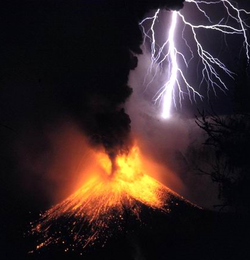
1995 eruption of Mount Rinjani
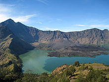
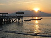
Mount Rinjani also known as Gunung Rinjani, is an active volcano on the island of Lombok. It rises to 12,224 feet or 3,726 meters,making it the second highest volcano in Indonesia. On top of the volcano is a 3.7 to 5.3 mile (6 by 8.5 kilometer) caldera, partially filled with water, that has become known as Segara Anak or Anak Laut (Child of the Sea). So called because of the incredible blue color of the lake. The astounding Gunung Rinjani National Park,is our 7th stop in the travel series A World Far and Away.
It is thought that the name Rinjani, comes from an old Javanese term for God.
Mount Rinjani as well as the caldera lake, are both part of the Gunung Rinjani National Park, which was established in 1997. Segara Anak Lake is near 6,600 feet (2000 meters) above sea level and is estimated to be about 660 feet or 200 meters deep.
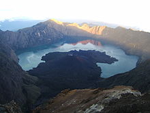
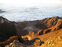
Segara Anak, the volcanic crater on the summit of Rinjani.
This caldera also contains hot springs. The most popular among these is Aik Kalak, at the crater rim.
The park sits inside a major bio-geographical transition zone, known as Wallacea. It is where the tropical flora and fauna of Southeast Asia meets that of Australasia.
The Sasak tribe and Hindu people, profess that both the lake and the mountain are sacred. As a result, a number of religious ceremonies are staged in the area.
The Balinese come to the Segara Anak Lake and perform a ceremony called Mulang Pakelem. During the procession, jewelry is placed in the lake, as an offering to the mountain spirit.
View of Segara Anak from the crater rim
This annual Hindu ceremony at the crater lake, dates from the 18th century invasion of Lombok,by Balinese from the kingdom of Karangasem. It attracts hundreds of white clad participants
The Wetu Telu also regard the lake as sacred. They will come on full moon nights, to pray and commune, with the larger spiritual world.
Rising from the waters of the lake is a new volcano known as Mt. Baru, which is a result of a series of eruptions, that occurred during the 1990’s.
In addition, there are three well known caves at the park. These are identified as Gua Susu, Gua Payung, and dan Gua Manik.
Mount Rinjani at sunrise
Tourism to the area has grown increasingly popular. Most recently, it has been interrupted due to geologic activity at various intervals. The summit route was closed for a time in July 2009 and again in early 2010, through May of that year, as volcanic activity increased.
September 2016 was the last eruption witnessed on Mount Rinjani, but the entire area remains geologically quite active.
In April of 2018, UNESCO made the Mount Rinjani Caldera, a part of the Global Geoparks Network.
View from the summit of Gunung Rinjani
The Gunung Rinjani National Park is comprised of 159.6 square miles or 41,330 hectares. The protected area includes a further 250 square miles (66,000 hectares) of forest.
In 2004, Mount Rinjani had obtained the World Legacy Award from Conservation International and Traveler. It was also a finalist for Tourism for Tomorrow Awards in 2005 and 2008 from the World Travel Tourism Council.
In December 2010, a photo of eruption of Mount Rinjani, won the National Geographic Photography Contest.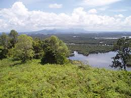
Tourists looking for an outdoor adventure, can traverse the park or engage in a climb to the summit of the mountain.
The view from the top is widely regarded, as being one of the best in the entire country of Indonesia.
Around the slopes of Mount Rinjani are vibrant forests, with a variety of exotic birds and animals, sprinkled with waterfalls and surrounded by outstanding scenery.
For visitors to the park, the three day Rinjani trek route from Senaru to the crater rim and then down 600 meters (1969 feet) down to the Crater lake, then moving on to Sembalun Lawang village, is considered one of the best hikes in all of Southeast Asia.
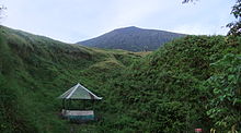
Hiking Post on Tengengean, 1500 m height on Mt. Rinjani
For those more adventurous travelers, a trek to the summit of the volcano itself will take four days from Sembalun Lawang, finishing up in the village of Senaru.
From the absolute peak, travelers can see Bali to the west and Sumbawa to the east.
The surrounding communities have benefited from the increased tourism, due to the business partnerships between the public and private sectors. Revenue from visitor activities and entry fees, is used for conservation and management of the park. This model is unique in Indonesia, and is one of the best examples of Eco-tourism in the country.
Location
Most visitors arrive to the park, from the village of Senaru, which is located on the northern side of the mountain. This is closer to the main resort areas of the west coast, including Senggigi. The other point of access would be from the village of Sembalun, on the eastern side of the mountain, which is far closer to the summit.
Both of these villages can be accessed from the main north coast road.
Phone: +62 (0) 370-660-8874
Website: info@rinjaninationalpark.com
Admission
The entry price to the park is Rp 150,000, the equivalent of $10.61 USD (United States Dollar), per person. From this fee, 13% is allocated to the park, 62% to the Rinjani Trek Eco-tourism Program and 25%, to support the Rinjani Trek operation and maintenance program.
Rinjani Park regulations, stipulate the use of a certified guide.
Tourists need to make sure when organizing a travel package, that it is made with the Rinjani Trek Management Board (RTMB). The RTMB has only one main office, located at the Lombok Raya Hotel in Mataram.
There are also representative offices at the Rinjani Trek Center in Senaru and Rinjani Information Center in Sembalun,both of which are located on the island of Lombok alone.
The official rate per person for a tour to the rim, consisting of two days and one night, with a twin share will cost $300 USD.
The trek to the Summit, which will take 3 days and two nights, will cost the equivalent of $350 USD per person, with a twin share.
A hike to the Lake, for 3 days and 2 nights, is available at $350.00 USD per person, with a twin share.
The Summit Lake trip at 4 days and 3 nights, is $380.00 USD per person, with a twin share.
Days and Hours of Operations
Typically, the hike to the rim involves two days and one night on the mountain. The longer ascent to the summit, can be done with just one extra night’s camping, but is often part of a longer trek of 3 to 4 days and 2 or 3 nights.
Lodging
- Is available in the villages of Sembalun and Senaru.
Valuable Tips
- Few tourists actually make the very strenuous effort required to reach the actual summit, but instead stop at the crater rim. To make the extra 1,000 meter (3281 feet) ascent to the very top, requires a far higher level of fitness.
- Serious accidents and even fatalities have occurred, when just using a guide. Therefore, it is best not to try to make the trek alone. Go as part of an organized group.
- Proper climbing or hiking boots are recommended.
- A wind and waterproof jacket is a necessity.
- A head lamp will also be needed.
- If you are going all the way to the top, use of poles to use as walking sticks are highly recommended.
Very informative blog! Would like to read more such blogs by you. Keep up the good work :))
Hello Sir!! It’s very Nice article and nice blog for all time!! Thank you for providing such a good article!!
Thank you
Exploring different places is my passion, I follow my passion with full dedication and that’s why I take followup from different blog and your blog is one of it.
Mount Rinjani looks awesome! Cool pictures, would love to visit one day
It’s a magnificent place. You’ve got some incredible photos there!
Super Artikel und Bilder auch .. !!!!
interesting articles and this is my first first reading a very interesting article thanks for this article that fits with the theme news.
agen poker online terbaik indonesia
interesting articles and this is my first first reading a very interesting article thanks for this article that fits with the theme news.
poker online terbaik
Wow. Very offbeat topic and very well written article, love the pictures you’ve put 🙂
Sounds like an amazing adventure! This was such an informative post too, well done