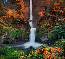
 Multnomah Falls is located in the Colombian River Gorge and can be found in northwestern Oregon. Spanning two tiers on basalt cliffs, it is the tallest waterfall in the state at 620 feet or 189 meters. There are many travelers that consider the site, to be Americas most beautiful waterfall. It is the 27th stop in our travel series Off The Beaten Path.
Multnomah Falls is the most visited natural recreation area in the Pacific Northwest, with over two million visitors annually. They provide a year round attraction for tourists, that is absolutely stunning in natural beauty.
According to the legend from the native Multnomah tribe, the waterfall was formed after a young woman sacrificed herself to the Great Spirit, by jumping over the cliff. She did this to save the Multnomah village from a plague. After her death, water began to flow from above the cliff, thus creating the waterfalls.

Multnomah Falls in the early years of tourism circa 1915.
Another Native American story tells that the Falls were created, to win the heart of a young princess who wanted a hidden place to bathe.
The Falls are credited by the United States Forest Service, as being the second tallest year-round waterfall in the United States.
This distinction is in dispute, as the World Waterfall Database does not differentiate between seasonal and year round waterfalls. It lists Multnomah as the 156th tallest waterfall in the country.
The Multnomah Falls are ranked 434 in height, globally. The Falls encompass a 10 foot (3M), average width.
Multnomah Falls consist of cascades of water that drop in two major steps. There is the Upper Falls of 542 feet or 165 meters and Lower Falls of 69 feet or 21 meters. In between there is a 9 foot drop in elevation between the two. These two separate drops are the result of more easily eroded basalt, at the base of the Upper Falls.

The falls while frozen in December 2013.
Larch Mountain provides underground springs, which are the year-round source of water for Multnomah Creek. Runoff from snow in the spring and rainwater throughout the year, supplement this supply, which maintain the falls constant flow.
However, late winter and early spring is when the water is most abundant and therefore making the falls most spectacular.
The land surrounding the falls, was developed by Simon Benson in the early 20th century. Over time, he constructed an easily traversed pathway, and a viewing bridge.
In early 1915, the Portland Progressive Business Men’s Club organized an effort to build a trail from the base of Multnomah Falls, extending to the top of Larch Mountain.
The Club along with Portland financier Simon Benson,who pledged an additional $3,000 USD (United States Dollar), worked to fund the project.
The United Forest Service agreed to add $1,500 USD to the undertaking. The government agency agreed to survey and engineer the trail to a lookout, on top of the mountain.

Benson Bridge
Benson for his part, financed Italian stonemasons to design and construct a bridge at the Falls, which would permit future visitor access.
Named Benson Footbridge, it spans the Lower Falls at the height of 105 feet. It also provides an expansive view of the Upper Falls.
A paved foot trail leads to the 45 foot Benson Footbridge. It allows travelers to cross 105 feet above the lower cascade.
After providing a viewpoint of the Upper Falls, the trail continues to ascend to an elevation of 785 feet.
The pathway then later descends to an observation deck, 660 feet overlooking the edge of the Falls. From there one can view the Colombia Gorge and the Little Multnomah Falls,located further up the stream.

Wahkeena Falls
The same year, Benson donated over 1,400 acres or 570 hectares of land, which included most of the Multnomah Falls, as well as nearby Wahkeena (most beautiful in the Yakima language)) Falls to the city of Portland.
The 240 feet high Wahkeena Falls, are accessible by a 0.6 mile trail.
A mile high trail from the base of Wahkeena Falls to the top, is quite popular among locals for its spellbinding views, wildflowers and lack of larger crowds of tourists. These falls are presently closed due to the 2017 Eagle Creek Fire
The Oregon and Navigation Company, would donate the land at the base of the Falls. This was done by agreement, that a lodge would soon be built at the site.
Architect A. E. Doyle was commissioned by the city of Portland, to build Multnomah Falls Lodge in 1915. It was constructed in the Cascadian architectural style, using native split field stones laid irregularly.

Multnomah Falls Lodge and Footpath
The lodge features, a steep pitched cedar shingled gable roof. Included in the design are a number of large chimneys for heating and dormers for the windows.
Through the mid part of the 20th century, travelers could obtain both accommodation and meals at the Multnomah Falls Lodge.
Today there is still a restaurant on the second floor, that serves breakfast,lunch and dinner. There is also a visitor and interpretive center, snack bar, and a gift shop.
The Lodge completed in 1925 and the surrounding footpaths, were added to the National Register of Historical Places in 1981.

Colombian River Gorge
Today, the state of Oregon maintains a switchback trail that ascends to a rock formation, that is 100 feet above the Falls. This pathway descends to an observation deck that overlooks the edge of the Falls.
There are a number of trails that lead out from the main pathway. These allow access to nearby waterfalls.
The Falls themselves, would be later donated from the city of Portland to the National Forest Service.
Multnomah Falls were formed about 15,000 year ago,likely the creation of the Missoula Floods, at the end of the last ice age.

Missoula Floods
The now famous Falls were identified by the famous early American explorers William Clark and Meriwether Lewis, during the 1805 expedition through the Columbia River Gorge.
The actual naming of the Multnomah Falls remains a mystery. It has been suggested that a prominent mercantile clerk in Portland by the name of S.G. Reed, may have been the first to use the moniker.
His objective would have been to popularize sites along the Colombia River, for the new steamboat excursions, that were taking place in the 19th century.
How To Get There
There are 3 different routes that one can take to arrive at the Multnomah Falls.
- The most direct is 30 miles from Portland, eastbound on Interstate 84. It will will take about a half-hour by car. The road signs will direct you to Exit 31, which will be on the left side. This will bring you to the parking area. The pathway under the highway, will take you to the viewing area.
- The Scenic Route will take about 45 minutes. From Interstate 84 you will take Exit 28 known as the Bridal Veil Exit. The extra 15 minutes will be well worth it. The three miles drive east on the Colombia River Gorge Scenic Highway, allows one to see a number of other waterfalls on the way.
- The Ultra Scenic Route will take at least an hour or more, depending if you make any stops to take a few photographs, which most tourists do. The view is utterly spectacular. Take Interstate 84 eastbound and depart the highway on the Troutdale Exit. This will take you to the Scenic Loop Drive, which is The Old Colombia River Highway. It was the first in the country, to be named a National Historic Landmark. One will be able to see Mount Hood, a number of other famous waterfalls and see various points of the Colombia River Gorge.
Arranging Transportation
If one does not have a car, or chooses not to deal with parking, one can take the Colombia Gorge Express Shuttle from Portland.
Mailing Address
Columbia River Gorge National Scenic Area Office

Simon Benson 1851- 1942
902 Wasco Avenue,
Suite 200
Hood River, Oregon 97031
Phone Number (541) 308-1700
Website: https://www.fs.usda.gov/recarea/crgnsa/recarea/?recid=30026
Entrance Fee
There are no fees, to visit either Multnomah Falls or Wahkeena Falls.
Days and Hours of Park Operations
The Visitor Center and the site in general, is open from 9:00 am to 5:00 pm.
Facilitates are open and available year round,7 days a week.
The Multnomah Falls Lodge Visitor Center phone number is (503) 695-2372.
Lodging
Is available in the city of Portland.
Helpful Hints
- Wear suitable footwear (closed-toes shoes), for walking and hiking outdoors.
- Pets are allowed at Multnomah Falls, but must be kept on a leash and under control.
- Spray and water mist do cause a cooler micro-climate, within the viewing area. A windbreaker is advisable in the spring and autumn. Warmer clothing will be needed in the winter time.
- The trail to the top of the falls on Larch Mountain from Benson Bridge is a mile hike up on a very steep path. It may often be closed, due to hazard conditions. There are steep drop-offs and the ground is uneven, as well as slick at times.
- Parking quickly fills up during the summer season, especially on weekends between the hours of 11:00 am to 4:00 pm. The gates close, once there is no more parking available.
Seriously this waterfall is gem of Oregon America. You portrayed the description of waterfall beautifully and that inspired me deeply. Thanks for share such a wonderful blog.
Gracias por la informacion!! Este tipo de blogs me parecen muy importantes, esto lo estudio en la universidad, donde los voy a compartir gustosamente con mis compañeros. gracias por la informacion. https://uautonoma.cl
Are guides needed to reach the falls? I love your photos!
Hey there,
Wonderful illustrated information. I thank you for that. No doubt it will be very useful for my future projects. Would like to see some other posts on the same subject!
For me too Iceland was a big favorite and I dream to go back in the summer to see the North. I only traveled around Reykjavík …and i love your photos <3
I love this article. oregon is one of the best place for tourists and beautiful waterfalls attracts more. Thanks for amazing post.
We visited these falls earlier this summer and have to say, they are indeed beautiful! It’s a shame that the recent fires have taken out much of the trees on the hike up now. From below it is still spectacular. It looks pretty cool with the ice on it! May have to go back in December 🙂 Thanks for sharing!